| Summer finally returned this past weekend. Temps in the 90s every day and not a cloud in the sky. Pretty offensive for Seattle standards, but there are better things to complain about! Unfortunately, I couldn’t make it out for a multi day affair since I got tickets to the BoDeans for my birfday. If you ask me, a pretty good reason not to be able to get out. The BoDeans were playing as part of “Mountain Music Fest” and we thought they were headlining, and (I) went solely because of them. They are a Wisconsin band and I regret to say I never saw them in the intimate confines of a local stage. But alas, I had my opportunity. The concert was at Marymoor park - a nice outdoor venue just on the other side of the lake. I should have read (or just known) that you can bring whatever you want in (besides EtOH?). people had like 3 coolers of crap for 3 people with chairs and everything. Us? Nothing. We got a big FAIL for that … next time I’ll plan a little more. So we got to see Sara Bareilles, Jacob Dylan, and Robert Randolph and the family and in addition to the BoDeans. The other three I could actually take or leave so we wandered around while listening/watching. The unfortunate thing is that the BoDeans were second on the stage and only had the stage for a limited time. They were hands down the best band out there with the most excitement so I wish they would have played longer and/or came out later. Anyway, good times, great weather and a good locale to wander around.
We were on the road at the early time of 9:45 and hiking just past noon. The bootpath started immediately and was on a ridge so we were greeted with views instantly. About 40 minutes after hiking on the ridge in and out of some nice forest we broke into the meadow just (S)W of the summit.
Approach notes: Everything that I saw (Beckey included) did not accurately describe the best approach. Take 530 to Darington. Stay on 530 (as opposed to the mountain loop hwy) and turn left at the stop sign (at the Shell station). After 0.25 mile, turn right on sauk prarie road. After about 1.5 miles (just less than) turn right on FSR 24 (unsigned from sauk prarie road). After 8 miles on 24, the road T’s. Turn left at this 'T' onto 2435 (2436 is to the right). Shortly thereafter, stay right at a minor junction. Then 2435 climbs steeply for a long while and reaches a ridge crest. It follows the ridge for a while, eventually descending steeply about 150 feet. About 0.25 miles after this descent take an unmarked spur to the right (~4600 feet). (Accidentally we took what appeared to be the main road to the left for a mile (+) which eventually dead ended at about 4300’). The spur dead ends in about 0.25 miles at ~4800 feet. An obvious boot path leads from the road. There are other approaches, but this is the highest starting point with the nicest/easiest path. |
Tuesday, August 17, 2010
White Chuck Mountain (6989' 8/15/10) and the BoDeans!!!!


Monday, August 2, 2010
Triumph on Triumph (7270'); Despair on (the route to) Despair
On Tuesday 7/27 after work Ryan, Lucas and I set out for our long trip of the summer. The intentions were to set up a car shuttle and hike from Thorton Lakes TH to Baker river TH, climbing many peaks and traversing other terrain features on the way: Triumph – Despair – Mystery Ridge – Hagan – Blum - and others? This would have been a great trip but it didn’t turn out as such for various reasons, but still was a great excursion with interesting ‘deviations.’
Day 1: We left Seattle Tue after work and did the car shuttle. We stopped in Marblemont to fill out the climbers permits and discovered that Lucas had a flat. After spending an h
Columbia Peak (7172' 7/24/10)
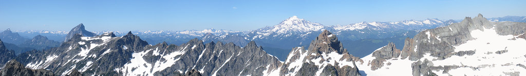
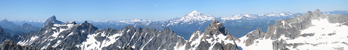
| While a horrific “fail,” our attempt of glacier peak was oddly fun. The bike ride made for an added dimension and if the going is right, makes for much quicker travel. Alison and I decided on the Monte Cristo environs (glacier basin) last weekend. Monte Cristo is a pretty cool place: an old mining town from way back in the day. I found the ruins of town to be a worthy destination for a laid back short day trip. The only access is via a 4 mile washed out road from leaving the mountain loop highway at Barlow pass. Besides one washout, the road is in great condition. We headed to monte cristo on our bikes, and arrived in about 90 minutes. Headed up to glacier basin on a nice trail and made camp. We saw some other campers and they pointed us to a great spot where we pitched the tent. It was only later that we realized that we really shouldn’t be camping in that area and there are places for more impacted on the knoll in the middle of glacier basin. After a quick lunch we decided to attempt Columbia. Per the route description, we made a rising traverse to Wilman gap (5oo feet of the gap, take a hard right up the glacier). We needed to do a fancy two step move to get onto the rock because of a moat, but nothing bad. We headed down and across the 76 glacier to meet the W spur route. From there, as described up a snow field. Unfortunately I went up a little too far and had to traverse steep snow over a very large moat adding a little unnecessary spice to the adventure. Went around the blind corner and started climbing what looked like class three. It ended up being a rotten gully terminating in slightly exposed class four climbing which only looked to get more difficult. I finally decided to poke my head around farther to the S face and every time I did the words “humph, why didn’t I just start over here” came out. Easy climbing led me back to the W face and another two step move got me past another moat to the final 20 feet to the summit. The summit was spectacular – 360 degree views without a cloud in the sky, and only slightly hazy. (The Panorama at the top is from the summit.) This was a really fun route and I really enjoyed the approach. Poodle dog pass is obviously more direct, but this approach added a lot of variability that I personally enjoyed. Not to mention the passing through glacier basin which was glorious in itself. The decent went without issue and we enjoyed a superb evening in camp. We ended up only tooling around the basin on Sunday and argued over the routes up to all of the other peaks in the area. Hopefully we’ll be back to climb those sometime soon (Monte Cristo, Foggy, Cadet, etc.). A stellar climb in a stellar setting. | See more pics here Who knew there would be a bike rack in Monte Cristo?  Poor pic, but it shows the route. Columbia is center, in the background. Took the snow as close to the rock as possible almost to the low point (left of pic). Took a sharp right to go behind Wilman peak (not discernable) to hit the col to glacier 76. 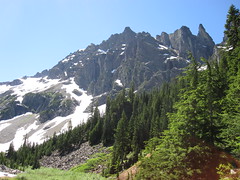 First snowpatch as heading up the W ridge. 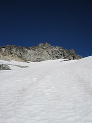 Dirty Gully on Summit block. Should have traversed farther right.  Baker and Shuksan from the summit 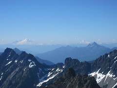 Puget Sound glistening in the Sunlight 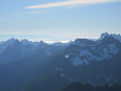 Alison at camp at sunset. Monte Cristo behind. 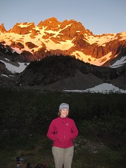 |
Subscribe to:
Posts (Atom)


