So the quest for springtime/summer brews continues. Thought I'd throw in a curveball and make ginger beer. The parent recipe, brewed way back when, was a fan fav. It was also based on my sis' recipe that just took third at a competition and is headed off to nationals! Go sis! I changed things up a bit and tried to use ingredients that were just laying around. The Major change was 3oz ginger at 10 min (previous batch) to 1.5oz at 30 and 10 min to get some flavor (will add significant bitterness). Also, used the lager yeast from the Pilsner just brewed (instead of an ale yeast).
For beer geeks. 3.25# maris otter 2 row, 3.0 canadian 2 row, 1 1/8# crystal 30, 3/8# munich, 1# malted wheat. No water additions to my filtered water. Mash in at 154 for 60 min and mash out at 170 for 5 min. Kettle schedule: 60 minute boil, 60 min: 1 oz spalt (4.1%); 30 MIN 1.0 oz grated ginger; 10 min 1.5 oz grated ginger and irish moss; 5 min 1 oz spalt. Chill and ferment at cellar temp (wyeast 2206 from pils), about 52-54 degrees.
unfortunately I didn't have enough ginger so I skimped a little. If need be I can dry hop with ginger in the secondary (dry ginger?). But the best part of this is that I started at about 6 after work and finished right at 10 or so! Maybe I'll brew after work more often. Target gravity 1.045, actual, 1.046.
Tuesday, April 14, 2009


Friday, March 6, 2009
Spalt Vs Saaz/Halertau Pilsner
With summer coming in I wanted to get some lighter, refreshing beers on tap. I decided to make another pilsner because I didn't have the time to think about something exciting or plan a new recipe. However, since I have an abundance of organic spalt hops I wanted to do an experiment. One mash, split to two boils and hop with either a spalt only schedule or a more typical Saaz --> Halertau schedule.
The described Spalt characteristic: Many include it in the list of noble hops. Some describe it as a very fine, pleasant spicy hop. I've seen "earthy" and a little "woody" used as well. Mine are a little old and might have tended to the earthy, a little musty end.
So the recipe is for 11 gallons, plus a little extra that I used to make and can yeast starters. Target 1.045 with an 78% mash efficiency.
for beer geeks. 17# pils malt, 1.5# vienna malt, 0.5# crystal 10 degree. No water additions to my filtered water. Mash in at 118 (a tad low) for thirty min, raise to 150 for 60 min mash out at 170 for 5 min. Wanted 2.5 gallons of starters @ 1.030 so I took out 1.6 gal wort + 0.8 gallons water for starters. Split remaining wort evenly to 2 kettles. Kettle schedule: 70 minute boil, 60 min: (kettle 1) 1 oz Saaz (kettle 2) 1 oz Spalt. 45 min (1) 1 oz saaz (2) 1 oz spalt. 30 (1) 1 oz halertau, (2) 0.9 oz spalt. 15 min (1) 1 oz Halertau, (2) 0.7 oz spalt. + irish moss. Note, I was on autopilot for the boil, times were intended to be 60, 30, 15, and 5. Oh well. Chill and pitch 2206 - bavarian lager. Only had about 4 gallons post boil so I added ~ 1 gallon water to make up volume. Ferment at cellar temp - 52-54 degrees.
Well, I hit the target gravity pretty well (1.044 for both). Fermentation took ~ 36 hours to start. :-( After the boils, I boiled up the starters with some yeast nutrient and did two rounds of canning. I should have plenty for awhile! Any Seattle based brewers are welcome to one in exchange for ..... beer stuff. :-)
And after the starters, it was off to clean up the basement. This was a sad, sad time. Apparently, after changing all of my lines a few days earlier, I didn't screw one of the fittings on tight and I of course put that on the 10 gallon carboy that was just filled to the brim. The result? A slow leak depositing the 10 gallons of beer all over the freezer floor, just noticed today! Beer foul in the highest degree! So I spent over an hour figuring out a way to clean up the disaster from the freezer, making a long day that much longer. So in the end, bitter sweet. 10 gallons of pilsner created, ten gallons IPA lost. Hopefully the Pils will turn out a be an acceptable replacement!
The described Spalt characteristic: Many include it in the list of noble hops. Some describe it as a very fine, pleasant spicy hop. I've seen "earthy" and a little "woody" used as well. Mine are a little old and might have tended to the earthy, a little musty end.
So the recipe is for 11 gallons, plus a little extra that I used to make and can yeast starters. Target 1.045 with an 78% mash efficiency.
for beer geeks. 17# pils malt, 1.5# vienna malt, 0.5# crystal 10 degree. No water additions to my filtered water. Mash in at 118 (a tad low) for thirty min, raise to 150 for 60 min mash out at 170 for 5 min. Wanted 2.5 gallons of starters @ 1.030 so I took out 1.6 gal wort + 0.8 gallons water for starters. Split remaining wort evenly to 2 kettles. Kettle schedule: 70 minute boil, 60 min: (kettle 1) 1 oz Saaz (kettle 2) 1 oz Spalt. 45 min (1) 1 oz saaz (2) 1 oz spalt. 30 (1) 1 oz halertau, (2) 0.9 oz spalt. 15 min (1) 1 oz Halertau, (2) 0.7 oz spalt. + irish moss. Note, I was on autopilot for the boil, times were intended to be 60, 30, 15, and 5. Oh well. Chill and pitch 2206 - bavarian lager. Only had about 4 gallons post boil so I added ~ 1 gallon water to make up volume. Ferment at cellar temp - 52-54 degrees.
Well, I hit the target gravity pretty well (1.044 for both). Fermentation took ~ 36 hours to start. :-( After the boils, I boiled up the starters with some yeast nutrient and did two rounds of canning. I should have plenty for awhile! Any Seattle based brewers are welcome to one in exchange for ..... beer stuff. :-)
And after the starters, it was off to clean up the basement. This was a sad, sad time. Apparently, after changing all of my lines a few days earlier, I didn't screw one of the fittings on tight and I of course put that on the 10 gallon carboy that was just filled to the brim. The result? A slow leak depositing the 10 gallons of beer all over the freezer floor, just noticed today! Beer foul in the highest degree! So I spent over an hour figuring out a way to clean up the disaster from the freezer, making a long day that much longer. So in the end, bitter sweet. 10 gallons of pilsner created, ten gallons IPA lost. Hopefully the Pils will turn out a be an acceptable replacement!
Thursday, March 5, 2009
March comes in like a lion
... as the saying goes, "March comes in like a lion." Is that a good thing? ... i guess it depends. This year the lion came in and appeared to bite my head off. This is why there have been few (i.e. zero) posts recently, and I need to vent one last time, so excuse the verbosity and melodramatics. So the story goes like this....
Because the yard and carport were full of fallen trees I was parking on the street. After a fine Friday soccer game (we beat our nemesis!) I parked and walked to the bar for some celebratory beverages. Life was great. Unfortunately I woke to a call on Sat morning more or less informing me that my car was stolen. The worst part (well, that's debatable) is that my bike was in the hatchback. So both means of transportation were gone ... like that. A moment for the bike - it was my first road bike and it was a fun ride. I thought it was a fun little toy and everyone that worked on it thought it was cool for what it was. So now it's gone with the car. So insurance, blah blah blah. The worst part is that I literally felt my disposition to fellow strangers changed overnight. Now instead of looking at everyone and assuming good, it's the opposite and I am much more guarded. It's not really how I want to live, but the few rotten apples in the bushel have gotten to me. ok, enough philosophizing and all in all, I know that this is insignificant and worse things happen to tons of people everyday, but it just yanked my confidence in society right out form me.
And then it was like all the tiny things that could go wrong went wrong. ... well, not all of them, but enough of them! I got sick and felt miserable for a month. There was a leak in a keg and 10 gallons of freshly made yummy homebrew spewed all over the freezer (holy mess batman, and holy beer foul batman), spending way too much time/stress in the yard taking care of the trees, insurance crap, dryer broke, coffee carafe decided to jump off the drying rack (life without coffee!?!!?!?!??!), dealing with the end of the seattle winter waiting for su, so on and so forth. So I spent much of March moping around and dealing with those issue. So yeah, all pretty minor, but cumulatively they took a toll. boo hoo hoo. So yeah, I should stop my whining and get over it. I guess it's time to get out in the mountains again and start writing about it. Will do!
So the car will come back, but the bike will be gone. I found it posted on craigslist the following morning. Sucked seeing it being sold right under my nose. it was a fun little toy. Hopefully the new owner will enjoy it as well, and karma will be just to those that deserve it.
Because the yard and carport were full of fallen trees I was parking on the street. After a fine Friday soccer game (we beat our nemesis!) I parked and walked to the bar for some celebratory beverages. Life was great. Unfortunately I woke to a call on Sat morning more or less informing me that my car was stolen. The worst part (well, that's debatable) is that my bike was in the hatchback. So both means of transportation were gone ... like that. A moment for the bike - it was my first road bike and it was a fun ride. I thought it was a fun little toy and everyone that worked on it thought it was cool for what it was. So now it's gone with the car. So insurance, blah blah blah. The worst part is that I literally felt my disposition to fellow strangers changed overnight. Now instead of looking at everyone and assuming good, it's the opposite and I am much more guarded. It's not really how I want to live, but the few rotten apples in the bushel have gotten to me. ok, enough philosophizing and all in all, I know that this is insignificant and worse things happen to tons of people everyday, but it just yanked my confidence in society right out form me.
And then it was like all the tiny things that could go wrong went wrong. ... well, not all of them, but enough of them! I got sick and felt miserable for a month. There was a leak in a keg and 10 gallons of freshly made yummy homebrew spewed all over the freezer (holy mess batman, and holy beer foul batman), spending way too much time/stress in the yard taking care of the trees, insurance crap, dryer broke, coffee carafe decided to jump off the drying rack (life without coffee!?!!?!?!??!), dealing with the end of the seattle winter waiting for su, so on and so forth. So I spent much of March moping around and dealing with those issue. So yeah, all pretty minor, but cumulatively they took a toll. boo hoo hoo. So yeah, I should stop my whining and get over it. I guess it's time to get out in the mountains again and start writing about it. Will do!
So the car will come back, but the bike will be gone. I found it posted on craigslist the following morning. Sucked seeing it being sold right under my nose. it was a fun little toy. Hopefully the new owner will enjoy it as well, and karma will be just to those that deserve it.

Tuesday, February 17, 2009
The Brothers - 2/15/09
I've never been to the area, but I've wanted to try my luck at the brothers for awhile. You can see them standing by themselves from Seattle, and they mock me every time I drive West on a surface street in Seattle. From my understanding, late season climbs of the brothers can be a bugger due to overgrown brush. So, with the nice weather I went over the past weekend with my skis (being optimistic) to try to get some turns in and make things (possibly) easier.
Road to Lena lakes was snow covered, and impassible for my tiny golf 1 mile from TH. Thanks to Mike and jared from Port orchard for the ride to the TH. 'Great,' I thought, 'sufficient snow!' 100 feet into the trail skis went on my back, and unfortunately they never left that perch. Trail was crystal clear to Lena Lakes. From Lena Lakes, trail is snow covered, but easily navigable (no skis). Camped at the fork in the stream (3000').
Sunday, we had to boot through avy/fire debris until about 4500'. We wasted much energy navigating the downed trees, especially with the sticks on my back in AT boots. There wasn't enough snow cover to just walk/skin through, as I was hoping. We finally hit continuous snow at ~4500' but I still booted to a headwall at ~5000'. We decided to turn around there because of our late start, weather coming in (started to snow), and fatigue from jumping around trees. I probably could have gotten a 750' run with my skis, but I didn't want to mess with the skins, etc.
Got back to TH at dark, and I finally got to put on the skis for the first time just to tour back to the car through the slush.
I am sure there was some skiing to be had up top, but the ~8+ miles each way in AT boots wasn't worth it for me. At least I got to bring some of the Olympic National park back with me - attached to the skis! Hopefully I'll be back to finish them off shortly .... but this time a little more prepared.
Road to Lena lakes was snow covered, and impassible for my tiny golf 1 mile from TH. Thanks to Mike and jared from Port orchard for the ride to the TH. 'Great,' I thought, 'sufficient snow!' 100 feet into the trail skis went on my back, and unfortunately they never left that perch. Trail was crystal clear to Lena Lakes. From Lena Lakes, trail is snow covered, but easily navigable (no skis). Camped at the fork in the stream (3000').
Sunday, we had to boot through avy/fire debris until about 4500'. We wasted much energy navigating the downed trees, especially with the sticks on my back in AT boots. There wasn't enough snow cover to just walk/skin through, as I was hoping. We finally hit continuous snow at ~4500' but I still booted to a headwall at ~5000'. We decided to turn around there because of our late start, weather coming in (started to snow), and fatigue from jumping around trees. I probably could have gotten a 750' run with my skis, but I didn't want to mess with the skins, etc.
Got back to TH at dark, and I finally got to put on the skis for the first time just to tour back to the car through the slush.
I am sure there was some skiing to be had up top, but the ~8+ miles each way in AT boots wasn't worth it for me. At least I got to bring some of the Olympic National park back with me - attached to the skis! Hopefully I'll be back to finish them off shortly .... but this time a little more prepared.
Monday, February 16, 2009
Climbing - Tree Style
 I like trees, really I do. My lot line had 7 of them. For such a small area that's a lot. I tried to maintain them (kinda), but they've outgrown their welcome and are killing everything in my neighbor's and my yards. So I got an urge to re-landscape and do something else on the lot(line). So I convinced a friend to help take them down, so sad. I had seen a company do my neighbor's huge pine and that involved a man lift, how were we (read David) going to take them down? Oh, just climb them. Really? Yes, I found out Friday.
David arrived with much of his climbing gear. Ascenders, harness, ropes, climbing shoes (ok, spurs), Belay devices, slings. biners, saws (ok, I can't think of a climbing use of saws - maybe trail maintenance?), and more.
He started climbing up the tree with his spurs and a sling around the tree. He cleared the limbs on his way up (pic left) and took out the trunk on his way down (pick right about ready to top the one tree). Simple. I moved the branches around on the ground, got David some water, some food, and whatever else he
 wanted.
So we got three and a half down. We had to stop there since we lost daylight and I had no where else to put the stuff he was dropping to the ground. I guess, to be cntd... but before it's on to cleanup (pic left showing the growing green pile covering the entire backyard).
David in a pose that would make Sarah Palin proud!

Monday, February 9, 2009
Kaleetan Peak 2/7/09
The original plan was to take a ferry and climb the Brothers on a two day ski/climb. The weather man put an end to that calling for a crappy Sunday, so we decided to do a one day climb in the Snoqualmie area - Kaleetan peak. After 2 days of numerous email threads creating 3 different parties, Ryan, Lucas, and I finally were on our way at the upper alpental lot at 6:00 in the morning. We were glad that we decided against Chair Peak as it looked like everyone was heading that way for a cluster &^%k.
We pretty much did the chair peak circumnavigation in the clockwise direction with the excursion to Kaleetan, however we deviated from the normal route by taking the S ridge route instead of the shorter E face. From Melakwa lake we traversed W past some cliff bands then ascended the south face which looked like a beautiful ski. I led up thanks to my ski crampons while the others took their own lines. The going wasn't easy on skis up on the jagged ridge so we dropped about 400 feet on the west side on a really nice run. Not knowing what to expect we threw the skis on our backs and hiked from there. Awhile later we arrived at the summit - on a gorgeous sunny day.
This turned out to be one of the nicest climbs in the area for me - a little more remote, a little more difficult, and gorgeous weather and views for the day. We ended up skiing the upper gully which I just made a mess of --- also, the snow pack is really getting thin. The S face just below the summit gully was wonderful and the E face, which was most parties chosen ascent route, was steep with some nice soft snow. Again, I made a mess of this. So, after being completely humbled by the two steep sections we skinned up to Melakwa pass for a rest. We finished the circumnavigation via chair lake, snow lake, and source lake, finally meeting up with the other groups at the Issaquah Brewhouse. ~5600' up and the same down. 'Twas a gorgeous climb.


We pretty much did the chair peak circumnavigation in the clockwise direction with the excursion to Kaleetan, however we deviated from the normal route by taking the S ridge route instead of the shorter E face. From Melakwa lake we traversed W past some cliff bands then ascended the south face which looked like a beautiful ski. I led up thanks to my ski crampons while the others took their own lines. The going wasn't easy on skis up on the jagged ridge so we dropped about 400 feet on the west side on a really nice run. Not knowing what to expect we threw the skis on our backs and hiked from there. Awhile later we arrived at the summit - on a gorgeous sunny day.
This turned out to be one of the nicest climbs in the area for me - a little more remote, a little more difficult, and gorgeous weather and views for the day. We ended up skiing the upper gully which I just made a mess of --- also, the snow pack is really getting thin. The S face just below the summit gully was wonderful and the E face, which was most parties chosen ascent route, was steep with some nice soft snow. Again, I made a mess of this. So, after being completely humbled by the two steep sections we skinned up to Melakwa pass for a rest. We finished the circumnavigation via chair lake, snow lake, and source lake, finally meeting up with the other groups at the Issaquah Brewhouse. ~5600' up and the same down. 'Twas a gorgeous climb.
Sun coming up in the morning.

Laying the track up to Bryant col

Heading up the slope to the S ridge.

Kaleetan from the S ridge.

Booting it up the summit gully on Kaleetan.

Me making a turn at the top of the summit gully.

Lucas descending from Melakwa pass to Chair lake.

Sunday, February 1, 2009
Isolation Traverse. Aug, 2008
Excuse the late post. This happened during the summer of 2008. I'll be updating more pics and cleaning things up, but I'm just getting it out to force myself....
90 percent heaven and 10 percent hell. That’s all I can say. I will try to describe the proceedings, but 90 percent heaven and 10 percent hell. This was probably the toughest trip that I have endured when you combine psychological, physical, and environmental factors. It is also probably the best (to date). So excuse the ramblings. ... also I think lucas captured the tone of the trip with the music for the youtube video at the end. It was a very invigorating trip, but humbling and pensive as well. Video well done L.
Mark and Jamie wanted to return to the N Cascades – to the country they love – and do another ‘epic’ trip. We had previously done the ptarmigan traverse which to our accords was ‘epic.’ We decided on the “isolation traverse” or the “inspiration traverse” after long discussions. Mark had mentioned this traverse when I just started hiking in the N cascades and it seemed so awesome, extreme, and undoable at the time. Maybe that gave me the motivation to want to do it… if it was possible for me. We decided to do it from N to S, just because. Because that is what I had in mind and that is how many trip reports have described, although Lowell Scoog described the S to N traverse more beneficial for skiing because of the elevation ups and downs. Nonetheless, we planned for the N to S trip.
Lucas and I arrived home from my sister’s wedding and the Wind River trip on Tuesday. Mark and Jamie came into town on Wednesday. We prepped on Thursday and Friday we set out for the pyramid lake TH after the car shuttle. After dropping my car at take out we stopped at the Marblemont café for breakfast and some yummy, gooey cinnamon rolls. We ended up talking about their rabbits which got Lucas on a most entertaining rant. But then again, it could have been the raisons in his bun. Also, they seemed scared of city folk even though they must get a $hit ton of tourist business, but to their defense we were kind of roudy because of the rabbits – so who can blame them. It was a yummy breakfast, but I digress.
We arrived at the TH and hiked up to pyramid lake for a rest. We continued up the ‘climber’s path’ to get to the colonial glacier. The path we were on had the one and only mission to go up as fast and steeply as possible, which took a toll on our energy reserves. We made it to the foot of the Colonial glacier, but were too wiped to keep going. We really wanted to get to the colonial – Neve glacier divide to centrally locate ourselves for the climbing, but incoming weather was the final straw to solidify the choice to stay put. We made camp and dove into our respective tents to avoid the weather.
We were pelted by rain and wind all night. Our tent didn’t fair so well but we didn’t get too wet to deter us from the rest of the trip. We got up late morning after the rains ‘subsided’ and planned to make a quick go of colonial peak and then move camp to the Neve glacier. We could see the route, which looked straightforward, so we left the rope and stuff at camp and headed toward colonial peak. Bouncing from snowfields to talus, we made it to a steep snow finger of colonial which we climbed to talus. After arriving at the talus, Lucas and I continued up to the summit – another ~750 feet. We had “lunch” and descended back to camp. Lucas lost his mouthpiece to his hydration bladder that I luckily saw 5 minutes behind him. …after a few personal experiences and then this one with 6 days to follow, an extra mouthpiece will be added to the first aid kit (along with the space blanket from last month). We arrived back at camp to some fierce winds and weather, had a quick bite to eat and retreated into the tents…. Needless to say, we did not move up to the Neve glacier, in effect losing a day on the itinerary. Pictured (left) is Lucas coming back to camp with Colonial in the background seen through the intermittent clouds.
Sunday (8/3) we woke late to blueish skies. We had said that by midmorn if the weather hadn’t improved we would bail, maybe this was a sign of what was to come. With the better weather we packed up camp to try to get to – or past the Neve glacier with some climbs in. I was a pent up bundle of energy so I quickly packed up ran down around Colonial Lake to the glacier and flaked out the rope, got all the knots set, tied in, and ‘patiently waited.’ Eventually the group joined me and we were slogging up the glacier. We stopped halfway at a “flatish spot,” secured our packs and headed N towards Pyramid peak. Pyramid is a group of three peaks, pyramid, pinnacle, and Paul Bunyans Stump (reverse order when referring to elevation). Pyramid is by far the easiest and more or less a walk up. Single file on the rope we all climbed to the saddle between pyramid and pinnacle where we then dropped the rope and gear and ran up to the summit. This turned out to be the first, and only summit (pic right with Baker et al in background) that the four of us would experience. It was gr
 eat weather, we had great views, and we hung out for a while. We even got a shot of the four of us doing the summit dance – which I must interject originated as an inane sun dance during the N. Pickets traverse with insanely horrendous weather. We danced, celebrated, and prepared for the descent. On the way down, I wanted to climb the other two peaks, but we didn’t really have time. I convinced Lucas to climb Paul Bunyans stump. Mark and Jaime seemed disinterested but agreed to hang out while we attempted. My thought was with a name like that, how can’t you climb it, and it is the tallest peak of the three. Lucas and I climbed to the S side of the stump (pic left from the entry onto rock from the snow S of the stump), scrambled up around the West and finally up the N-ish ridge to the summit (class 3+; 45 minutes from M&J on the glacier). We had some food, took some pics, and called down via the radios to report back. We then down climbed to the packs on the colonial, where we met back up with Mark and Jamie.
We continued up to the Colonial:Neve col in short time (Pic right is our routes on Pyramid from the vantage point of the Colonial Neve col). This is where things got difficult. Mark and Jamie couldn’t continue and we had to say our goodbyes. We had hoped to spend a night here but weather pushed us back a day and with good daylight to be had Lucas and I decided to forge on. We wanted to do the traverse all together, as we had done on others before, but those cards were not in the mix. This unfortunately sat ill in my/our mind/s through the rest of the trip. (I might add that I had no clue what lay ahead, but whatever it was, I would gladly take it to down climbing the wretched ‘trail’ we ascended.) So bidding farewell, Lucas and I continued across the Neve while Mark and Jamie headed back down to pyramid TH. The Neve glacier was relatively long and uneventful (pic right from Colonial:Neve col with Snowfiled to the left). We had to jump a few cracks, but that’s part of the fun. We dropped our packs between the horseman and Snowfield and made a dash for snowfield. We climbed class 3 and then got off route. We wandered for a bit and I probably got onto low class 5 stuff to the summit, crapping my pants the latter part of the way. In retrospect, the key is staying on the W ridge, but just S of the crest. Stay just S of the ridge via an obvious path and once you get to a huge boulder blocking the path, continue up/around the boulder (instead of calling it a dead end and turning around because downclimbing looks too sketchy like we did) and downclimb about 20 feet. This leads to a nice, easy class three scramble to the summit. Instead, we traversed just N of the ridge which led us to a doable low class 5 route that got the adrenaline going. In the late afternoon we summited the third peak of the day and hung out, contemplating the rest of the day’s events. We studied the next part of the path and tried to figure our plan of attack. We decided on the ideal camp and would go from there. (pic left is Mcallister glacier and eldorado behind, amongst all the other awesome things in the area)

We downclimbed back to the packs and headed pretty much due SSW to try to hit the tarns on the ridge close to isolation. We hadn’t realized that there was a gorge-like feature that made things impassable. The two options were to climb down then up or vice versa – both of which involved climbing up, which didn’t make us happy. We decided to climb up to where the two ridges met. In retrospect we should have headed due S, or even SSE from the snowfield:horseman col that would have taken us directly to the correct ridge. Descending to the ridge I took a spill and twisted my knee, which was a burden throughout the trip. But we made it down to the ridge, and flat beautiful tarns and made camp as the sun was setting. This was probably the nicest camp on the trip and after the days events – saying out good byes, 3 summits, 2 glaciers, a ton of elevation and mileage, and a spill – we needed to relax and had some (a lot of) whiskey. (pic just below, sunset at camp with a halo over Baker)

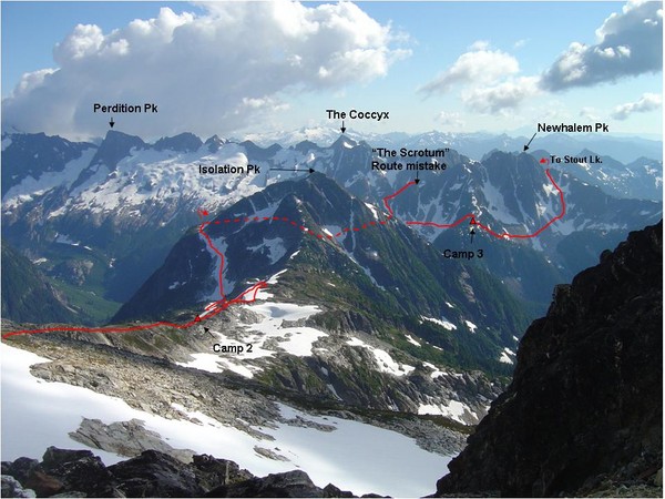
Monday (8/4). We woke up to blue skies and enjoyed the camp for awhile. (pic left is our route from late day 2, day 3, and early day 4) We continued on the ridge and made our way down to the lake just NE of isolation (isolation lake???), traversed the lake and headed up an obvious snow field until about 1000 feet from the summit. Here is where things got “fun.” (pic right, isolation lake mid morning) We were too tired (or thought we were) to climb isolation and figured we could traver se/descend to the ridge leading to Wilcox lakes. So we set off across talus and this quickly led to cliff bands, densely thatched cedars, and steep slick heather slopes. Slowly, painfully, and carefully we picked our way through the crap and in about 45 minutes arrived at the proper ridge and on much easier terrain. This was indeed part of the 10% hell but short lived, and at least I have a few more hairs on my chest. I don’t know if there is a way around it. If I had to do it over again, I would lug my full pack up to the summit and try to directly get on the ridge leading to Wilcox
 lakes. Reconnaissance made it look doable, but maybe not better in terms of bushwacking and evil down climbs (but hey it’s another remote peak). We took a bath at Wilcox lakes, hung out and rested for a couple of hours, and thoroughly enjoyed the cascading tarns of the area.
We continued on the ridge and started ascending. We climbed to a ridge E of Newhalem peak. We thought there would be a way down into the valley and back up for an entrance onto backbone ridge. Once we got to the ridge we decided that there was no way down into the valley and up to backbone ridge. Well, it looks like that’s the route that Lowell Skoog describes, but we didn’t want to bushwack it. We decided to try to stay on the ridge and climb a nob and make it over to the S side of newhalem. When we got to the top of the nob we found that it cliffed out and dropped a good 200 feet or so straight down and didn’t connect with Newhalem at all. We might have been able to rappel and climb, but that would have been a last resort. At this point we were a little unhappy and keeping with being in line with backbone ridge and the coccyx we named the nob “the scrotum.” We retraced our steps and made it to a shoulder just NW of the scrotum where we made camp.
Tuesday (8/5). We woke up to more blue skies, thankfully, and continued our way through this maze that we had started…. We figured once we were on backbone ridge we’d be set – but how to get there? Since a lot of climbs of backbone ridge start from Stout lake, we headed there. We aimed for the col W of newhalem, but first we’d have to get off the shoulder and onto the talus field. No options loo ked good and L and I went out by ourselves to find the path of least resistance… Or is it the path of most resistance when you are going down??? Anyway, L made it down magically and I was a little envious until I found out that much of it was (un)controlled sliding and down climbing sketchy stuff. A little extra hunting and I found a nice trivial route. We climbed to the col just W of newhalem where we could see stout lake. On the way, L even found part of an airplane that had crashed the previous decade. It’s here where we realized that most of the route descriptions that we had (which were only a handful) had described and labeled things incorrectly or incompletely. We forewent Newhaven, which would have been an easy scramble. It had been the source of many problems and we wanted to conserve energy so we didn’t want to give it the time of day, and instead, descended to stout lake, which was straight forward with some bushwacking. Down at s
 tout lake, we breaked for a while, found a well stocked fishing camp, and decided on the route up to the next ridge. Well, deciding was easy since there was one and only one obvious way up. So we bushwacked through some dense small thatched trees … slowly. Pleasantly surprised we made it into open areas in about 30 minutes and continued up to the ridge. Once there we were overjoyed with an obvious, straight forward shot to backbone ridge. Note that the summit just S, or SE (I believe) has been referred to as the bat in previous descriptions, which is a mis-nomer (again, I believe). Anyway, once on the ridge we needed to pass through one more cirque. We climbed up the ridge and traversed snow and talus, just under the coccyx. We were so close to the coccyx and it looked so entertaining, we decided to drop out packs and go for it.
We donned crampons, got the rope, grabbed our ice axes some pickets and off we went. The head wall was very steep and fun. We set minimal protection and belayed up the snow wall. Class 3 after that it was easy going. A fun climb … and now we could enjoy it bec ause route finding issues were going to be a lot easier and we were a little calmer (pic left, an interesting pic just above the snow and below the summit; pic right, backbone ridge from the summit). We enjoyed the summit and returned to the packs, where we discovered that a marmot, most likely, had stolen my spork, an empty fuel canister, and some other shiny object that I forget
 --- I hope (s)he is making great use of them. We cruised to back bone ridge and traversed half of it until we decided to make camp with the sun setting (pic right).
Wed (8/6). So even with all of the route finding issues to date, we still had what we perceived to be the crux of the trip – getting from backbone ridge to the Mcallister glacier. We continued on backbone ridge and onto marble glacier. We saw what would have been an easy crossing and made our way towards it, only to realize that we were too far NW, and that there was no glacier on the other side of the ridge, only steep rock/cliffs. So to bide time, we decided to head for Early Morning Spire to see if anything popped out at us. The marble glacier was fun, easily navigating the few horizontal crevasses (pic left, route on the glacier). We dropped our packs for early morning spire. Moats had formed around the rock so it took a few athletic-ish moves to get on the rock for a class three run to the summit (pic left, lucas on early morning spire with eldorado in back). I finished my stash of water, but didn’t figure that would be a problem since we were bound to find water en route. Ok, times up, how to get on the Mcallister? I figured that the Praying Mantis is class 3/ 4 on both sides so we could just go up and over that. Of course we’d rapel on the other side. L didn’t like the ideal of climbing that with full packs (I didn’t push hard at all), so we decided to aim for a low spot in the ridge and figure out how to rapel from there. We climbed to the rock. It was doable, but uncomfortable with full packs. I climbed without my pack, set a
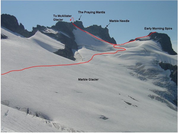
 top rope, rappelled, and then we belayed each other to the crest. We set a sketchy rappel to make it down to the mcallister. By sketchy I mean loose, wet, rock/dirt, that feels like it’s going to go at any time. It didn’t and we made it onto the mcallister. I think this turned out to be Lucas’ least favorite part of the trip – especially since he was the first to rap. The first few minutes on the glacier were tough going, very steep downclimbing with a lot of crevasses around and what appeared to be snow bridges of unknown strengths. Once we started traversing we high tailed it out of the area to a far safer part of the glacier where we could take in the scenery. The down climbing on snow ended up being my least favorite (sketch wise) part of the trip… probably because I was leading it. (pic right, Mcallister glacier. From left to right: Dorado needle, part of the Mcallister, Marble needle, snowfield not connected to the glacier, and the praying mantis at the halfway point across the photo. Our entry was just to the right (NW) of that where the snow finger goes up) So we traveled across th
 e McCalister, onto the inspiration, to the Eldorado glacier. Unfortunately, weather was rolling in for the first time since the Colonial glacier. It was a great stretch in which we lucked out with weather… but why bring in weather now?!?!? We decided to go for Eldorado and ran up to the summit quickly. This was going to be the culmination of the trip and L had never ascended plus it was the highpoint of the trip – we had to do it. Ascent/descent was uneventful (pic left lucas nearing the summit on the snow arete) and we were soon traversing/descending the eldorado glacier. We finally made it to the foot of the glacier – the first drops of water since early in the day (needless to say, I was quite dehydrated and bonking). We rested, filled up on water and carried on to the ridge between roush creek and eldorado creek, for yet another great camp with evening colors, pic right. For me thi
 s was another killer day – both in terms of exhaustion and for what we did. Killer in 100%, the most positive way.
Thurs (8/7). We packed up in the morning and headed out the climber trail to my car stashed at the TH. We had a couple of beers (stashed in the car) and bathed in the creak. Stopped at Good Food on the way home yelling and screaming about the awesomeness of the trip and how we were going to top it in the summer of 2009.
90% heaven and 10% hell. One can say that all trips have the hell part associated with them. We cursed and moaned because of the 10% hell, but in reality it just adds to the experience. The 90% heaven overshadows any of that, making this one of the best (if not the best) experiences for me in the back country …. To date.
Gear: USGS eldorado map (much more detail than green trails), rope (and ATC; our 50m was just good for rapel to mcallister), various slings/rapel loops, pickets, larger nuts (useful on certain climbs, but not used).
Here's Lucas description on cascade climbers
90 percent heaven and 10 percent hell. That’s all I can say. I will try to describe the proceedings, but 90 percent heaven and 10 percent hell. This was probably the toughest trip that I have endured when you combine psychological, physical, and environmental factors. It is also probably the best (to date). So excuse the ramblings. ... also I think lucas captured the tone of the trip with the music for the youtube video at the end. It was a very invigorating trip, but humbling and pensive as well. Video well done L.
Mark and Jamie wanted to return to the N Cascades – to the country they love – and do another ‘epic’ trip. We had previously done the ptarmigan traverse which to our accords was ‘epic.’ We decided on the “isolation traverse” or the “inspiration traverse” after long discussions. Mark had mentioned this traverse when I just started hiking in the N cascades and it seemed so awesome, extreme, and undoable at the time. Maybe that gave me the motivation to want to do it… if it was possible for me. We decided to do it from N to S, just because. Because that is what I had in mind and that is how many trip reports have described, although Lowell Scoog described the S to N traverse more beneficial for skiing because of the elevation ups and downs. Nonetheless, we planned for the N to S trip.
Lucas and I arrived home from my sister’s wedding and the Wind River trip on Tuesday. Mark and Jamie came into town on Wednesday. We prepped on Thursday and Friday we set out for the pyramid lake TH after the car shuttle. After dropping my car at take out we stopped at the Marblemont café for breakfast and some yummy, gooey cinnamon rolls. We ended up talking about their rabbits which got Lucas on a most entertaining rant. But then again, it could have been the raisons in his bun. Also, they seemed scared of city folk even though they must get a $hit ton of tourist business, but to their defense we were kind of roudy because of the rabbits – so who can blame them. It was a yummy breakfast, but I digress.
We arrived at the TH and hiked up to pyramid lake for a rest. We continued up the ‘climber’s path’ to get to the colonial glacier. The path we were on had the one and only mission to go up as fast and steeply as possible, which took a toll on our energy reserves. We made it to the foot of the Colonial glacier, but were too wiped to keep going. We really wanted to get to the colonial – Neve glacier divide to centrally locate ourselves for the climbing, but incoming weather was the final straw to solidify the choice to stay put. We made camp and dove into our respective tents to avoid the weather.
We were pelted by rain and wind all night. Our tent didn’t fair so well but we didn’t get too wet to deter us from the rest of the trip. We got up
 late morning after the rains ‘subsided’ and planned to make a quick go of colonial peak and then move camp to the Neve glacier. We could see the route, which looked straightforward, so we left the rope and stuff at camp and headed toward colonial peak. Bouncing from snowfields to talus, we made it to a steep snow finger of colonial which we climbed to talus. After arriving at the talus, Lucas and I continued up to the summit – another ~750 feet. We had “lunch” and descended back to camp. Lucas lost his mouthpiece to his hydration bladder that I luckily saw 5 minutes behind him. …after a few personal experiences and then this one with 6 days to follow, an extra mouthpiece will be added to the first aid kit (along with the space blanket from last month). We arrived back at camp to some fierce winds and weather, had a quick bite to eat and retreated into the tents…. Needless to say, we did not move up to the Neve glacier, in effect losing a day on the itinerary. Pictured (left) is Lucas coming back to camp with Colonial in the background seen through the intermittent clouds.
Sunday (8/3) we woke late to blueish skies. We had said that by midmorn if the weather hadn’t improved we would bail, maybe this was a sign of what was to come. With the
 better weather we packed up camp to try to get to – or past the Neve glacier with some climbs in. I was a pent up bundle of energy so I quickly packed up ran down around Colonial Lake to the glacier and flaked out the rope, got all the knots set, tied in, and ‘patiently waited.’ Eventually the group joined me and we were slogging up the glacier. We stopped halfway at a “flatish spot,” secured our packs and headed N towards Pyramid peak. Pyramid is a group of three peaks, pyramid, pinnacle, and Paul Bunyans Stump (reverse order when referring to elevation). Pyramid is by far the easiest and more or less a walk up. Single file on the rope we all climbed to the saddle between pyramid and pinnacle where we then dropped the rope and gear and ran up to the summit. This turned out to be the first, and only summit (pic right with Baker et al in background) that the four of us would experience. It was gr
 eat weather, we had great views, and we hung out for a while. We even got a shot of the four of us doing the summit dance – which I must interject originated as an inane sun dance during the N. Pickets traverse with insanely horrendous weather. We danced, celebrated, and prepared for the descent. On the way down, I wanted to climb the other two peaks, but we didn’t really have time. I convinced Lucas to climb Paul Bunyans stump. Mark and Jaime seemed disinterested but agreed to hang out while we attempted. My thought was with a name like that, how can’t you climb it, and it is the tallest peak of the three. Lucas and I climbed to the S side of the stump (pic left from the entry onto rock from the snow S of the stump), scrambled up around the West and finally up the N-ish ridge to the summit (class 3+; 45 minutes from M&J on the glacier). We had some food, took some pics, and called down via the radios to report back. We then down climbed to the packs on the colonial, where we met back up with Mark and Jamie.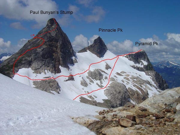
We continued up to the Colonial:Neve col in short time (Pic right is our routes on Pyramid from the vantage point of the Colonial Neve col). This is where things got difficult. Mark and Jamie couldn’t continue and we had to say our goodbyes. We had hoped to spend a night here but weather pushed us back a day and with good daylight to be had Lucas and I decided to forge on. We wanted to do the traverse all together, as we had done on others before, but those cards were not in the mix. This unfortunately sat ill in my/our mind/s through the rest of the trip. (I might add that I had no clue what lay ahead, but whatever it was, I would gladly take it to down climbing the wretched ‘trail’ we ascended.) So bidding farewell, Lucas and I continued across the Neve while Mark and Jamie headed back down to pyramid TH. The Neve glacier was relatively long and uneventful (pic right from Colonial:Neve col with Snowfiled to the left). We had to jump a few cracks, but that’s part of the fun. We dropped our packs between the horseman and Snowfield and made a dash for snowfield. We climbed class 3 and then got off route. We wandered for a bit and I probably got onto low class 5 stuff to the summit, crapping my pants the latter part of the way. In retrospect,
 the key is staying on the W ridge, but just S of the crest. Stay just S of the ridge via an obvious path and once you get to a huge boulder blocking the path, continue up/around the boulder (instead of calling it a dead end and turning around because downclimbing looks too sketchy like we did) and downclimb about 20 feet. This leads to a nice, easy class three scramble to the summit. Instead, we traversed just N of the ridge which led us to a doable low class 5 route that got the adrenaline going. In the late afternoon we summited the third peak of the day and hung out, contemplating the rest of the day’s events. We studied the next part of the path and tried to figure our plan of attack. We decided on the ideal camp and would go from there. (pic left is Mcallister glacier and eldorado behind, amongst all the other awesome things in the area)
We downclimbed back to the packs and headed pretty much due SSW to try to hit the tarns on the ridge close to isolation. We hadn’t realized that there was a gorge-like feature that made things impassable. The two options were to climb down then up or vice versa – both of which involved climbing up, which didn’t make us happy. We decided to climb up to where the two ridges met. In retrospect we should have headed due S, or even SSE from the snowfield:horseman col that would have taken us directly to the correct ridge. Descending to the ridge I took a spill and twisted my knee, which was a burden throughout the trip. But we made it down to the ridge, and flat beautiful tarns and made camp as the sun was setting. This was probably the nicest camp on the trip and after the days events – saying out good byes, 3 summits, 2 glaciers, a ton of elevation and mileage, and a spill – we needed to relax and had some (a lot of) whiskey. (pic just below, sunset at camp with a halo over Baker)

Monday (8/4). We woke up to blue skies and enjoyed the camp for awhile. (pic left is our route from late day 2, day 3, and early day 4) We continued on the ridge and made our way down to the lake just NE of isolation (isolation lake???), traversed the lake and headed up an obvious snow field until about 1000 feet from the summit. Here is where things got “fun.” (pic right, isolation lake mid morning) We were too tired (or thought we were) to climb isolation and figured we could traver
 se/descend to the ridge leading to Wilcox lakes. So we set off across talus and this quickly led to cliff bands, densely thatched cedars, and steep slick heather slopes. Slowly, painfully, and carefully we picked our way through the crap and in about 45 minutes arrived at the proper ridge and on much easier terrain. This was indeed part of the 10% hell but short lived, and at least I have a few more hairs on my chest. I don’t know if there is a way around it. If I had to do it over again, I would lug my full pack up to the summit and try to directly get on the ridge leading to Wilcox
 lakes. Reconnaissance made it look doable, but maybe not better in terms of bushwacking and evil down climbs (but hey it’s another remote peak). We took a bath at Wilcox lakes, hung out and rested for a couple of hours, and thoroughly enjoyed the cascading tarns of the area.
We continued on the ridge and started ascending. We climbed to a ridge E of Newhalem peak. We thought there would be a way down into the valley and back up for an entrance onto backbone ridge. Once we got to the ridge we decided that there was no way down into the valley and up to backbone ridge. Well, it looks like that’s the route that Lowell Skoog describes, but we didn’t want to bushwack it. We decided to try to stay on the ridge and climb a nob and make it over to the S side of newhalem. When we got to the top of the nob we found that it cliffed out and dropped a good 200 feet or so straight down and didn’t connect with Newhalem at all. We might have been able to rappel and climb, but that would have been a last resort. At this point we were a little unhappy and keeping with being in line with backbone ridge and the coccyx we named the nob “the scrotum.” We retraced our steps and made it to a shoulder just NW of the scrotum where we made camp.
Tuesday (8/5). We woke up to more blue skies, thankfully, and continued our way through this maze that we had started…. We figured once we were on backbone ridge we’d be set – but how to get there? Since a lot of climbs of backbone ridge start from Stout lake, we headed there. We aimed for the col W of newhalem, but first we’d have to get off the shoulder and onto the talus field. No options loo
 ked good and L and I went out by ourselves to find the path of least resistance… Or is it the path of most resistance when you are going down??? Anyway, L made it down magically and I was a little envious until I found out that much of it was (un)controlled sliding and down climbing sketchy stuff. A little extra hunting and I found a nice trivial route. We climbed to the col just W of newhalem where we could see stout lake. On the way, L even found part of an airplane that had crashed the previous decade. It’s here where we realized that most of the route descriptions that we had (which were only a handful) had described and labeled things incorrectly or incompletely. We forewent Newhaven, which would have been an easy scramble. It had been the source of many problems and we wanted to conserve energy so we didn’t want to give it the time of day, and instead, descended to stout lake, which was straight forward with some bushwacking. Down at s
 tout lake, we breaked for a while, found a well stocked fishing camp, and decided on the route up to the next ridge. Well, deciding was easy since there was one and only one obvious way up. So we bushwacked through some dense small thatched trees … slowly. Pleasantly surprised we made it into open areas in about 30 minutes and continued up to the ridge. Once there we were overjoyed with an obvious, straight forward shot to backbone ridge. Note that the summit just S, or SE (I believe) has been referred to as the bat in previous descriptions, which is a mis-nomer (again, I believe). Anyway, once on the ridge we needed to pass through one more cirque. We climbed up the ridge and traversed snow and talus, just under the coccyx. We were so close to the coccyx and it looked so entertaining, we decided to drop out packs and go for it.
We donned crampons, got the rope, grabbed our ice axes some pickets and off we went. The head wall was very steep and fun. We set minimal protection and belayed up the snow wall. Class 3 after that it was easy going. A fun climb … and now we could enjoy it bec
 ause route finding issues were going to be a lot easier and we were a little calmer (pic left, an interesting pic just above the snow and below the summit; pic right, backbone ridge from the summit). We enjoyed the summit and returned to the packs, where we discovered that a marmot, most likely, had stolen my spork, an empty fuel canister, and some other shiny object that I forget
 --- I hope (s)he is making great use of them. We cruised to back bone ridge and traversed half of it until we decided to make camp with the sun setting (pic right).
Wed (8/6). So even with all of the route finding issues to date, we still had what we perceived to be the crux of the trip – getting from backbone ridge to the Mcallister glacier. We continued on backbone ridge and onto marble glacier. We saw what would have been an easy crossing and made our way towards it, only to realize that we were too far NW, and that there was no glacier on the other side of the ridge, only steep rock/cliffs. So to bide time, we decided to head for Early Morning Spire to see if anything popped out at us. The marble glacier was fun, easily navigating the few horizontal crevasses (pic left, route on the glacier). We dropped our packs for early morning spire. Moats had formed around the rock so it took a few athletic-ish moves to get on the rock for a class three run to the summit (pic left, lucas on early morning spire with eldorado in back). I finished my stash of water, but didn’t figure that would be a problem since we were bound to find water en route. Ok, times up, how to get on the Mcallister? I figured that the Praying Mantis is class 3/
 4 on both sides so we could just go up and over that. Of course we’d rapel on the other side. L didn’t like the ideal of climbing that with full packs (I didn’t push hard at all), so we decided to aim for a low spot in the ridge and figure out how to rapel from there. We climbed to the rock. It was doable, but uncomfortable with full packs. I climbed without my pack, set a
 top rope, rappelled, and then we belayed each other to the crest. We set a sketchy rappel to make it down to the mcallister. By sketchy I mean loose, wet, rock/dirt, that feels like it’s going to go at any time. It didn’t and we made it onto the mcallister. I think this turned out to be Lucas’ least favorite part of the trip – especially since he was the first to rap. The first few minutes on the glacier were tough going, very steep downclimbing with a lot of crevasses around and what appeared to be snow bridges of unknown strengths. Once we started traversing we high tailed it out of the area to a far safer part of the glacier where we could take in the scenery. The down climbing on snow ended up being my least favorite (sketch wise) part of the trip… probably because I was leading it. (pic right, Mcallister glacier. From left to right: Dorado needle, part of the Mcallister, Marble needle, snowfield not connected to the glacier, and the praying mantis at the halfway point across the photo. Our entry was just to the right (NW) of that where the snow finger goes up) So we traveled across th
 e McCalister, onto the inspiration, to the Eldorado glacier. Unfortunately, weather was rolling in for the first time since the Colonial glacier. It was a great stretch in which we lucked out with weather… but why bring in weather now?!?!? We decided to go for Eldorado and ran up to the summit quickly. This was going to be the culmination of the trip and L had never ascended plus it was the highpoint of the trip – we had to do it. Ascent/descent was uneventful (pic left lucas nearing the summit on the snow arete) and we were soon traversing/descending the eldorado glacier. We finally made it to the foot of the glacier – the first drops of water since early in the day (needless to say, I was quite dehydrated and bonking). We rested, filled up on water and carried on to the ridge between roush creek and eldorado creek, for yet another great camp with evening colors, pic right. For me thi
 s was another killer day – both in terms of exhaustion and for what we did. Killer in 100%, the most positive way.
Thurs (8/7). We packed up in the morning and headed out the climber trail to my car stashed at the TH. We had a couple of beers (stashed in the car) and bathed in the creak. Stopped at Good Food on the way home yelling and screaming about the awesomeness of the trip and how we were going to top it in the summer of 2009.
90% heaven and 10% hell. One can say that all trips have the hell part associated with them. We cursed and moaned because of the 10% hell, but in reality it just adds to the experience. The 90% heaven overshadows any of that, making this one of the best (if not the best) experiences for me in the back country …. To date.
Gear: USGS eldorado map (much more detail than green trails), rope (and ATC; our 50m was just good for rapel to mcallister), various slings/rapel loops, pickets, larger nuts (useful on certain climbs, but not used).
Here's Lucas description on cascade climbers
Subscribe to:
Posts (Atom)


